
KANCHANABURI is a province in Western Thailand which is 128 km west of Bangkok. It is the third largest province in Thailand. The total area of Kanchanburi is 19,483 sq.km. (Thailand has been divide politically to 77 provinces. The capital is Bangkok. The largest area is Chiang Mai, at 40,216 sq.km, and the second largest is Nakhon Ratchasima, a province in the northeast, at 20,494 sq.km.) Kanchanaburi has been divided into thirteen distinct districts: 1.Mueang Kanchanaburi, 2.Sai Yok, 3.Bo Phloi, 4.Sri Sawat, 5.Tha Maka, 6.Tha Muang, 7.Thong Pha Phum, 8.Sangkhla Buri, 9.Phanom Thuan, 10.Lao Khwan, 11.Dan Makham Tia, 12.Nong Prue, 13.Huai Krachao.

Map of Thailand 77 Provinces

Kanchanaburi Gate since 1831
The topography of this province include the Tanao Si Mountains (or Tenasserim Mountains), which run from north to south and are the natural border of Thai-Myanmar. The province is covered with rainforest, and there is an abundance of bamboo and broad-leaved trees. These mountains are on the north and west area of the province and slope down toward the south. The mountains’ rock formations are composed of limestone, granite, and traces of quartzite and schist. This wide variety of rock is home to many interesting caves in the Kanchanaburi Province.

The Physical Map of Kanchanaburi

The Three Pagodas, the border of Thai-Myanmar, Sangkla Buri District

Limestone Cliff, Vajiralongkorn Dam, Thong Pha Phum District

Bamboo on the bank of Khwae Yai River, Wat Nong Bua, Mueang Kanchanaburi District

Bamboo forest along the riverside of Khwae Noi River, Sai Yok District

Bamboo forest grows well on limestone mountains, Khwae Noi River, Sai Yok District
There are three main rivers in Kanchanaburi:
1. Khwae Yai flows from north to south, about 380 km in length. Its origin is in the Umphang District’s Tanao Si Mountains and flows through the Kanchanaburi Province. (Umphang is a district in Tak Province located in the north of Kanchanaburi.) It is called Mae Klong when it flows in the area of Umphang. It’s named the Khwae Yai River when it flows to the Srinagarindra Reservoir in the area of Si Sawat, a district in the north of Kanchanaburi. The river then flows through the Srinagarindra Dam and out to the central plain of Kanchanaburi Town. Khwae Yai well known from WWII for “The Bridge over the River Kwai”, a railroad bridge constructed to pass over this river.

The Physical Map of Kanchanaburi

The Headwaters of Khwae Yai, Si Sawat District

Khwae Yai River, view from the Bridge over the River Kwai, Mueang Kanchanaburi District

Khwae Yai River, view from Wat Nong Bua, Mueang Kanchanaburi District

Khwae Yai River, view from Wat Thung Lat Ya, Mueang Kanchanaburi District
2. The Khwae Noi River flows from north to south in a valley of the western most province.


Khwae Noi River, River Kwai Resotel Resort Kanchanaburi, Sai Yok District

Khwae Noi River, Tham Krasae Railway Station, Sai Yok District
3 Mae Klong River is formed from the merging of the Khwae Yai and Khwae Noi Rivers, centrally located near the town of Kanchanaburi. The local named this point “Na Mueang”‘ it means in front of the town. In the past, the people always live on the banks of the rivers and the main transport are rivers by boat and raft. The Mae Klong flows to the south and passes through the Ratchaburi and Samut Songkhram provinces before heading towards the Gulf of Thailand.

Mae Klong River, view from Somdej Phra Ynannasangvararam, the Late Supreme Patriarch Hall, Mueang Kanchanaburi Diatrict
There are plenty of tourist attractions in each province that include all types of nature, history, and culture. The most natural tourist attractions are along the banks of Khwae Noi River from Sangkhla Buri in the northwestern most of the province and the Khwae Yai River from Si Sawat District. If you want to explore and do interesting activities all over Kanchanburi, an extended stay would give you the best opportunity to do it all. It’s nice to visit year round!!
Nature: There are 7 national parks in Kanchanaburi
1. Erawan National Park, highlight; Erawan Waterfall and Phra That Cave
Erawan Waterfall is in Si Sawat District on the Provincial Highway No.3199. It is far from Kanchanaburi Town ahead to the north of province about 70 km. It is on the left side of Khwae Yai River. We can visit this waterfall year round.


Erawan Waterfall in Summertime, Si Sawat District
Phra That Cave is up to north of province where located not far from Sri Nagarindra Dam and Erawan Waterfall.
Phra That Cave, Si Sawat District: Thank you for the photos from
2.Sai Yok National Park, highlight; Sai Yoi Noi Waterfall, Sai Yok Yai Waterfall, Lawa Cave
Sai Yok Noi Waterfall is on the National Highway 323, Sai Yok Diatrict. By the way, a perfectly journey to Sai Yok Noi Waterfall is by train. The “Death Railway” is an amazing destination that is highly recommended.
Sai Yok Noi Waterfall, Sai Yok District
Climate change and drought have affected the flows of the waterfall, however the forested areas remain beautifully green!
Sai Yok Yai Waterfall is in the same area of Sai Yok National Park’s head office. It is a waterfall, which falls into the Khwae Noi River. It is accessible by the National Highway No.323. The distance from Kanchanaburi to Sai Yok Yai Waterfall is 100 km.
Sai Yok Yai Waterfall, Khwae Noi River, Thong Pha Phum District: Thank you for the photos from
3.Khuean Srinagarindra National Park, highlight: Huai Mae Khamin Waterfall, Nam Mut Cave, Pha Tat Waterfall
Huai Mae Khamin Waterfall is in Si Sawat Disttict on the the west side of Srinagarindra Reservoir. There are many ways to access the Huai Mae Khamin Waterfall: 1.Kanchanaburi – Srinagarindra Dam on the Provincial Highway No.3199. Follow the road to the Srinagarindra Dam and turn left onto the Rural Road No.6043 that passses Phra That Cave to Huai Mae Khamin Waterfall, about 254 km. 2.Kanchanaburi – Si Sawat District on the Provincial Highway No.3199 then take a ferry across Srinagarindra to the waterfall at Huai Mae Lamun, about 180 km. 3 It can also be accessed by boat at the piers of the Srinagarindra Reservoir, Mong Kathae Pier, Tha Kradan Pier, Srinagarindra Dam Pier. A boat trip generally takes 1 – 1.3 hrs.


Huai Mae Khamin Waterfall, Si Sawat District
In 2015 the area suffered the worst drought in recent memory. The Huai Mae Khamin Waterfall lacked water for a few months in the summer. This year is the same. The best time to visit this waterfall is October to February.


Ferry crosses Huai Mae Lamun to Huai Mae Khamin Waterfall, Si Sawat District

The Headwaters of Khwae Yai, Si Sawat District

Srinagarindra Reservoir, Si Sawat District

Floating Resort in Srinagarindra Reservoir, Si Sawat District
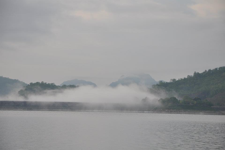

Srinagarindra Dam, Si Sawat District
4.Lam Khlong Ngu National Park, highlight: Nang Khruan Waterfall, Khliti Waterfall, Sao Hin Cave, Nok Nang Aen Cave, Nam Tok Cave, World Cup Cave
Lam Khlong Ngu National Park is located in the Thong Pha Phum District. It is far from Kanchanaburi, about 175 Km. The best way to access this beautiful park is to go to Thong Pha Phum District by the National Highway No.323 then turn right to the Rural Road No. 3087 for about 32 km.
The perfect time to visit this national park is in February – April or check out the announcement of Lam Khlong Ngu National Park. During rainy season, beware of flash flooding.
Nang Khruan Waterfall, Thong Pha Phum District, Thank you for the photos from
Khliti Waterfall, Thong Pha Phum District, Thank you for the photos from

Sao Hin Cave, The tallest stalagmite and stalactite, Thong Pha Phum District,
Thank you for the photos from
Nok Aen Cave, Thong Pha Phum District, Thank you for the photos from

World Cup Cave, Thong Pha Phum District, Thank you for the photos from
5.Chaloem Rattanakosin National Park, highlight: Than Lot Caves and Trai Trueng Waterfall
Chaloem Rattanakosin National Park is located in Si Sawat District. It is far from Kanchanaburi Town about 95 km. by the Provincial Highway No.3086.
Than Lot Caves, Si Sawat District, Thank you for the photos from

Trai Trueng Waterfall, Si Sawat District, Thank you for the photos from
6.Khao Laem National Park, highlight; Vajiralongkorn Reservoir, Dai Chong Thong Waterfall, Kroengkrawia Waterfall, Kratencheng Waterfall
Khao Laem National Park is located in the Thong Pha Phum and Sangkhla Buri Districts. It is far from Kanchanaburi Town about 181 km. by the National Highway No.323.
Vajiralongkorn Reservoir, Sangkla Buri District,
Thank you for the photos from https://www.facebook.com/kholaem.npk?fref=ts
The Mon Bridge is a beautifully constructed wooden bridge. It was built by Mon People, one of the ethnic groups of Myanmar who fled to Thailand because of tribal battle in Myanmar. They live in their community in Sangkhla Buri District. Their tradition has been well maintained and it is a very attractive destination for tourist.


Mon Bridge, Sangkla Buri District
Kratengcheng Waterfall, Sangkla Buri District, Thank you for the photos from
7.Thong Pha Phum National Park, highlight: Trekking to the top of Chang Phueak Mountain, Ban I-Tong, Pilok Mine, Chokkadin Waterfall.
Thong Pha Phum National Park is located on the Provincial Highway No.3272. From Kanchanaburi Town, follow the National Highway No.323 to Thong Pha Phum District then turn right to the Provincial Highway No.3272 about 204 km.

Noen Chang Suek, Ban I-Tong, Thong Pha Phum District

Viewpoint on Provinicial Higway No.3272, Thong Pha Phum National Park, Thong Pha Phum District

Vajiralongkorn Reservoir, Thong Pha Phum District

Fishing Village, Vajiralongkorn Dam, Thong Pha Phum District, Thank you for the photos from Mr. Håkan Larsson

Thong Pha Phum Town, a small town among the mountains, Thank you for the photos from Mr. Håkan Larsson
The Thung Yai Naresuan Wildlife Santuary is the largest wildlife sanctuary in Thailand and it is also in Kanchanaburi. It was declared a World Heritage Site in 1991 together with the Huai Kha Khaeng Wildlife Sancturay in Uthai Thani Province, on the northeast portion of Kanchanaburi. These two wildlife sanctuaries are a joint area of enormous rainforest, which covered Umphang Wildlife Sanctury. Portions of three wildlife sanctuaries merged together to form the Khao Laem , Lam Khong Ngu, Srinagarindra, and Mae Wong National Parks in Nakhon Sawan Provinces. These areas are home to a wide variety of biodiversity. Thung Yai Naresuan maintains some rare species of wildlife such as panthera pardus, panther tigris, tapir, hornbill.
Please read more detail from this link;
There are also many interesting nature sites, including the Khaonamphu Nature and Wildlife Education Center, as well as the Sangkhla Buri, Nopphibun Waterfall.
Historical Site:
1.Mueang Sing Historical Park, was located on the right bank of Khwae Noi river. It was built in the reign of Jayavaraman VII, (13th – 14th centuries) It’s Bayou Style temple. The transport from Kanchanaburi town by car is about 45 km. and by train only 27 km.


Mueang Sing Historical Park, Sai Yok District
2.Ban Kao National Museum, the prehistoric site before civilization is located on the east bank of the Khwae Noi River not far from Mueang Sing Historial Park. It is far from Kanchanaburi Town 35 km on the same route to Mueang Sing Historial Park.
3.Kanchanaburi Ancient Town, the contemporary town in the age of Ayutthaya is located in Tambon Lat Ya, Mueang Kanchanaburi District. It is far from the Kanchanaburi town toward to the north 20 km. on the same route to the Erawan Waterfall.
4.Death Railway/The Bridge over the River Kwai, the memorial of WWII, was constructed during the war with the purpose of connecting Southeast Asia to India by Japanese Army. They forced war prisoners from England, America, Australia, and Holland to, construct the railway and this well-known bridge. Tragically, during construction, many of the war prisoners were killed by malnutrition and malaria. A wonderful film from the 1960”s was made to tell the story of this bridge. It was a tremendous film, which portrayed the cruelties of World War II. It was a part of history where, hopefully, lessons were learned about the devastation of war.


The Bridge over the River Kwai, Khwae Yai River, Mueang Kanchanaburi District
Tham Krasae Viaduct, the Death Railway, Khwae Noi River, Sai Yok District
5.The Thai- Burmese Railway and Hellfire Pass, the memorial museum of WWII is located in Sai Yok District. This museum is included of indoor and outdoor exhibitions by Australian Foundation. Please see more details from the link below.
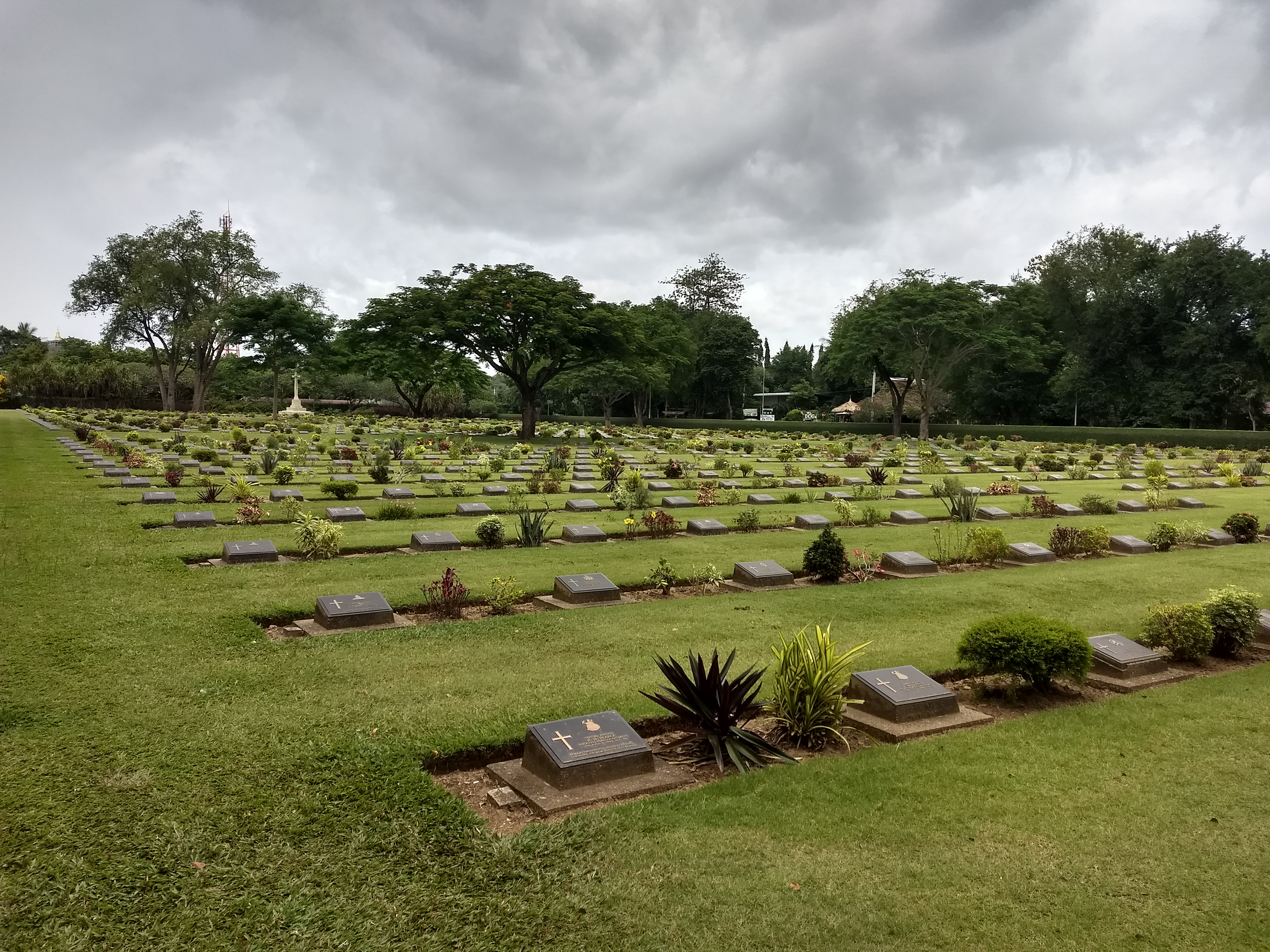
6.WWII Memorial Cemetery (Don Rak and Chong Kai)


Kanchanaburi War Cemetery, Don Rak, Mueang Kanchanaburi District
Kanchanaburi War Cemetery, Chong Kai, Khao Pun, Mueang Kanchanaburi District

Khwae Noi river at Kanchanaburi War Cemetery, Chong Kai, Kaho Pun, Mueang Kanchanaburi District
7. JEATH War Museum includes stories from Thailand’s allies as well as its enemies from WWII. JEATH is an abbreviation for Japan, England, America,Australia, Thailand, Holland. It is located at the end of Visuttharangsi Road, on the east bank of Mae Klong River. It is next to Wat Chai Chumphon Chana Songkhram or the local named Wat Tai. (“Tai”is Thai word means “south”} It is in southward of Kanchanaburi Town.

JEATH War Museum, Mueang Kanchanaburi District, Thank you for cover photo by Mr. Diedrich Saathoff on https://www.youtube.com/watch?v=yi0hbX4RYwA
Culture:
1.Wat Devasangharam is located in Kanchanaburi Town on the right bank of Khwae Yai. It is an important temple because the late supreme patriarch became a Buddhist Monk here. The memorial hall of the late supreme patriarch was built in the area of temple.

The memorial hall of the late supreme patriarch, Mueang Kanchanaburi District

Ficus Indica, the legend of the tree, it was cultivated by the late king of Thailand, Wat Devasangaram, Mueang Kanchanaburi District
2.Wat Dhipsugondharam is located in Huai Krachao District. It’s far from Kanchanaburi Town to the northeast, about 53 km. It is a nice place for meditation.

Ubosot Wat Dhipsugondharam, Huai Krachao District

Phra Buddha Metta Prachathai Trailokkanat Khandharrat Anusorn, Huai Krachao District
3.Wat Tham Suea and Wat Tham Khao Noi are located in Tha Muang District. It is on the bank of Mae Klong Dam.


Wat Tham Suea, Tha Muang District

Wat Tham Khao Noi, Tha Muang District

Wat Tham Khao Noi, Wat Tham Suea, Tha Muang District
4.Wat Tham Phu Wa is located in Mueang Kanchanaburi District. It is fine for mediation.


Wat Tham Phu Wa, a temple in the cave, Mueang Kanchanaburi District
5.The Floating Market is located in military area. It was built to replicate a scene from the film King Nares, the Great King of Siam in the reign of Ayutthaya.

Floating Village, Thai architecture style, Military Fort, Mueang Kanchanaburi District
6. Mallika R.E. 124, throw back to the way of life of Siamese in the reign of King Rama V,

Thai House in R.E.124, Sai Yok District
There are also many interesting places in Kanchanaburi awaiting tourists to visit. I will present the details of those interesting places in my next article. I think this article is too long to visit. So I will see you again the next time. Please wait and see!
Thank you for Mr.Micheal Joseph Piere
Everyone!!! Who gets a plan to visits Thailand and requires a traveling plans, please send text to me on Contact. I will give you a traveling plan and a free copy of Tout Thai Hi-Way Map 77 Provinces!!!

Wow – such beautiful scenery. I really like the look of the limestone mountains and the bamboo forest. Blogging is great for armchair travelling 🙂
LikeLiked by 1 person
Thank you! Yes, of course it so nice when It was made been armchair. 😀
LikeLiked by 1 person
Great post and photos!
Many thanks for stopping by and following my Travel and Photography blog. I have a post on Kanchanaburi if you’d like to have a read 🙂 https://imageearthtravel.com/2015/06/08/kanchanaburi-the-good-the-bad-and-the-ugly/
LikeLiked by 1 person
Thank you so much! 🙂 You are welcome! That’s great I will visit it!
LikeLike
Wow what awesome pictures. Thailand is one of my favorite places, your pictures make me want to go back soon. Thanks for the follow.
LikeLiked by 1 person
Thank you so much! That sounds great! Welcome to Thailand! 🙂 Thank you for following me! 🙂
LikeLiked by 1 person
Fantastic! 🙂
LikeLiked by 1 person
Thank you so much. Glad you like it. 😊
LikeLiked by 1 person
Fantastic! Thanks for taking me on an incredible journey!
LikeLiked by 1 person
Thank you so much. My pleasures.
LikeLike
A beautiful post on a beautiful place. I will think of these things next time I go to my favorite restaurant, which happens to be Thai. The scenery and architecture are just amazing.
LikeLiked by 1 person
That sounds great. I wish you will share your experience there via yore writing and photography. 🙂
LikeLiked by 1 person
Nice pics, kanchanaburi is definately on my to visit list.
LikeLiked by 1 person
Thank you so much! That sounds great! Welcome to Thailland. I’m making a map of Kanchanaburi. If you want it when you visit Thailand you can send an email to me. I will send it to you. Free copy.
LikeLike
Thanks that sounds great, I’ve lived in Thailand over six years and still never made it to Kanchanaburi, hopefully I will soon though =)
LikeLike
Nice! The perfect time to Kanchanaburi is the end of October – February. Anyway It’s such a province that can visits a year round. Have you read my text Ban I-Tong. It’s a charming village. The weather is so fine there.
LikeLiked by 1 person
I’ll check it out for sure
LikeLike
Nice! 🙂
LikeLike
Thank you so much for sharing this great report. Few month back my small family and I went to Kanchanaburi. It was the most beautiful vacation.
LikeLiked by 1 person
My pleasures. Nice to hear that you and your family have visitef there. It’s so green there now. Welcome to Thailand 😊
LikeLike